-

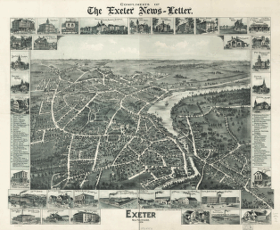
Exeter, New Hampshire, 1896. Compliments of the Exeter News-letter.
Price range: $39.95 through $69.95 -
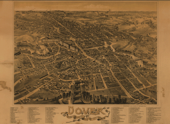
Dover, Stafford County, New Hampshire 1888.
Price range: $39.95 through $69.95 -
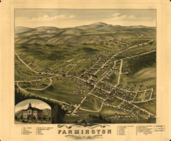
Bird's eye view of the village of Farmington, Stafford County, New Hampshire 1877.
Price range: $39.95 through $69.95 -
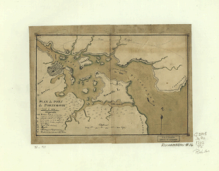
Plan du port de Portsmouth levé à vue.
Price range: $39.95 through $69.95 -
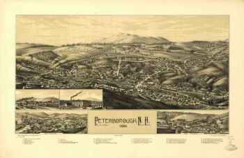
Peterborough, N.H. 1886. Drawn and published by L. R. Burleigh. Burleigh Lith. Establishment.
Price range: $39.95 through $69.95 -
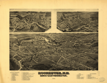
Rochester, N.H., Gonic and East-Rochester, 1884. H. Wellge, del.
Price range: $39.95 through $69.95 -
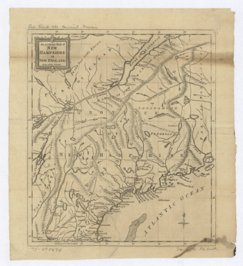
An Accurate map of New Hampshire in New England, from a late survey.
Price range: $39.95 through $69.95 -
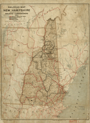
Railroad map of New Hampshire accompanying report of the railroad commissioners, 1894.
Price range: $39.95 through $69.95 -
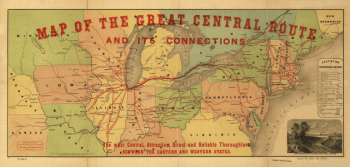
Map of the Great Central Route and its connections
Price range: $39.95 through $69.95 -
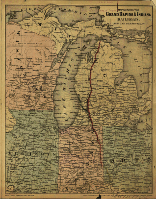
Map showing the Grand Rapids & Indiana Railroad, and its connections.
Price range: $39.95 through $69.95 -
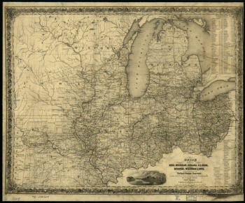
Guide through Ohio, Michigan, Indiana, Illinois, Missouri, Wisconsin & Iowa
Price range: $39.95 through $69.95 -
Birds eye view of the city of Hillsdale, Hillsdale Co., Mich. 1866. Drawn & published by A. Ruger.
Price range: $39.95 through $69.95 -
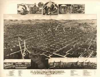
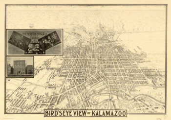
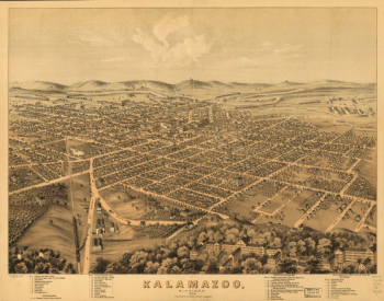
Bird's eye view of Kalamazoo, Mich. 1883. Drawn by H. Wellge & A. F. Poole. Beck & Pauli, lithographers.
Price range: $39.95 through $69.95 -
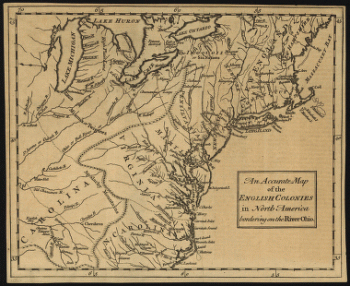
An accurate map of the English colonies in North America, bordering on the river Ohio.
Price range: $39.95 through $69.95 -
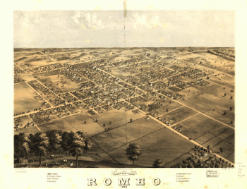
Bird's eye view of Romeo 1868. Drawn by A. Ruger. Chicago Lithogr. Co.
Price range: $39.95 through $69.95 -
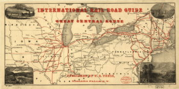
International rail road guide of the Great Central Route.
Price range: $39.95 through $69.95 -
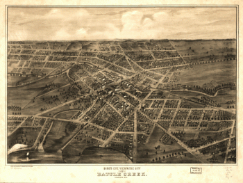
Bird's eye view of the city of Battle Creek, Calhoun Co., Mich. Drawn and published by A. Ruger.
Price range: $39.95 through $69.95 -
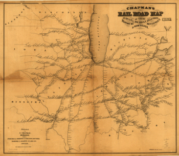
Chapman's rail road map of Ohio, Indiana, Michigan, Illinois, Missouri, Minnesota, & Wisconsin.
Price range: $39.95 through $69.95 -
Panoramic view of Mt. Clemens 1881, Macomb Co., Mich. Beck & Pauli, lith.
Price range: $39.95 through $69.95 -
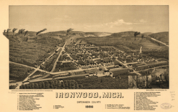
Ironwood, Mich., Ontonagon County 1886. H. Wellge, sk. Beck & Pauli, litho.
Price range: $39.95 through $69.95 -
Bird's-eye view of Kalamazoo / this drawing produced by the Benford-Bryan Co. Incorporated, artists.
Price range: $39.95 through $69.95 -
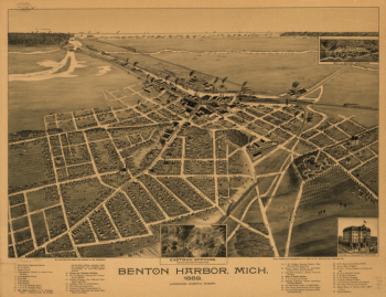
nton Harbor, Mich. 1889.
Price range: $39.95 through $69.95 -
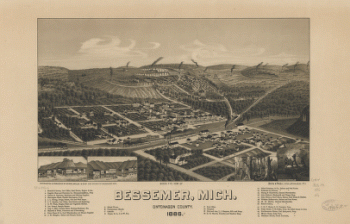
Bird's eye view of Bessemer, Mich., Ontonagon County 1886. Beck & Pauli, litho.
Price range: $39.95 through $69.95 -
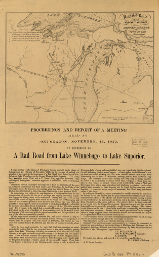
Proposed route for a rail road from Copper Harbor, to Fond Du Lac, Winnebego.
Price range: $39.95 through $69.95 -
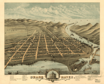
Grand Haven, Ottawa County, Michigan 1874. Chas. Shober & Co. props. Chicago Lithographing Co.
Price range: $39.95 through $69.95 -
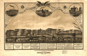
Mills & manufacturing establishments of the city of Battle Creek, Calhoun Co., Mich
Price range: $39.95 through $69.95 -
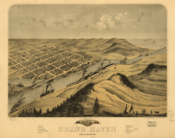
Birds eye view of the city of Grand Haven, Ottawa Co., Michigan 1868
Price range: $39.95 through $69.95 -
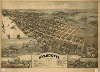
Wyandotte, Michigan 1896. Drawn by T. M. Fowler.
Price range: $39.95 through $69.95 -
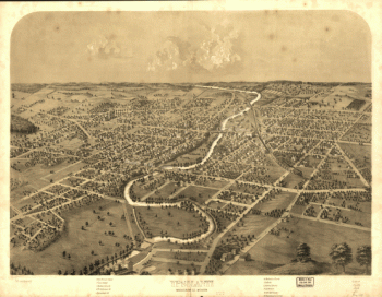
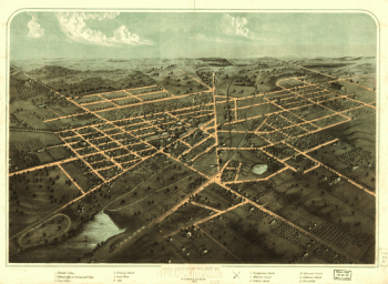
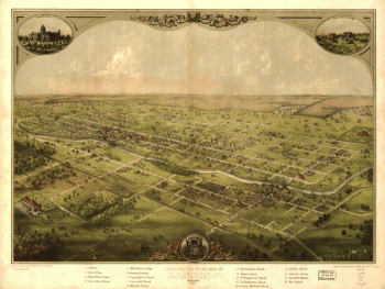
Panoramic view of the city of Jackson, Michigan 1881. [By] A. Ruger. Beck & Pauli Lith.
Price range: $39.95 through $69.95 -
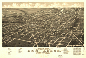
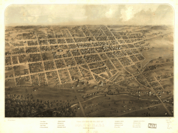
Panoramic view of the city of Ann Arbor, Washtenaw Co., Michigan 1880. Beck & Pauli Lith.
Price range: $39.95 through $69.95 -
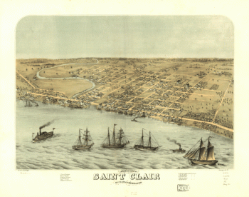
Bird's eye view of Saint Clair, St. Clair Co., Michigan 1868. Drawn by A. Ruger. Chicago Lith. Co.
Price range: $39.95 through $69.95 -
Kalamazoo, Michigan 1874. Chas. Shober & Co. props. Chicago Litho. Co.
Price range: $39.95 through $69.95 -
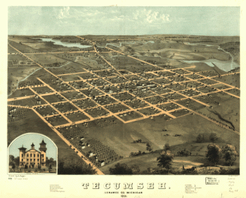
Tecumseh, Lenawee Co., Michigan 1868. Drawn by A. Ruger. Chicago Lithogr. Co.
Price range: $39.95 through $69.95 -
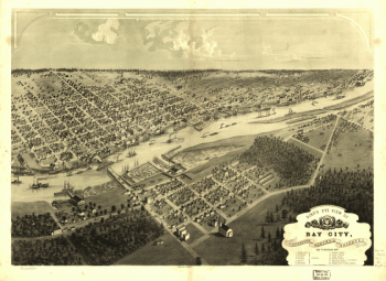
Bird's eye view of Bay City, Portsmouth, Wenona & Salzburg, Bay Co., Michigan 1867. Drawn by A. Ruger.
Price range: $39.95 through $69.95 -
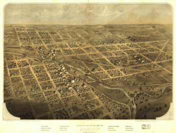
Birds eye view of the city of Albion, Calhoun Co., Michigan. Drawn & published by A. Ruger.
Price range: $39.95 through $69.95 -
Birds eye view of the city of Lansing, Michigan 1866. Drawn & published by A. Ruger.
Price range: $39.95 through $69.95 -
Birds eye view of the city of Coldwater, Branch Co., Michigan. Drawn & published by A. Ruger.
Price range: $39.95 through $69.95 -
Birds eye view of the city of Marshall, Calhoun Co., Michigan. Drawn & published by A. Ruger.
Price range: $39.95 through $69.95 -
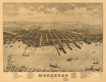
Bird's eye view of the city of Muskegon, Muskegon Co., Michigan 1868. Drawn by A. Ruger.
Price range: $39.95 through $69.95 -
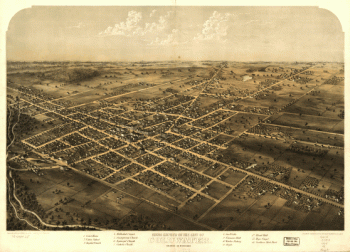
Saginaw City [Michigan 1867] Drawn from nature by A. Ruger.
Price range: $39.95 through $69.95 -
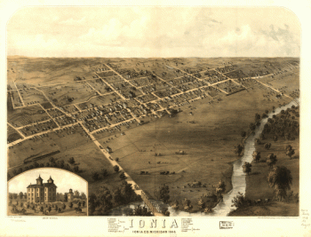
Ionia, Ionia Co., Michigan 1868. Drawn by A. Ruger.
Price range: $39.95 through $69.95 -
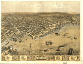
Muskegon, Michigan 1874.
Price range: $39.95 through $69.95 -
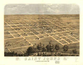
Saint Johns, Clinton Co., Michigan 1868. Drawn by A. Ruger.
Price range: $39.95 through $69.95 -
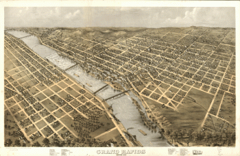
Grand Rapids, Michigan 1868. Drawn by A. Ruger.
Price range: $39.95 through $69.95 -
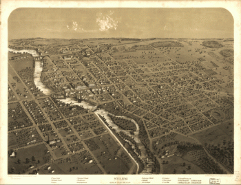
Niles, Berrien County, Michigan. Drawn & published by A. Ruger.
Price range: $39.95 through $69.95 -
Ypsilanti, Washtenaw Co., Michigan. Drawn & published by A. Ruger.
Price range: $39.95 through $69.95 -
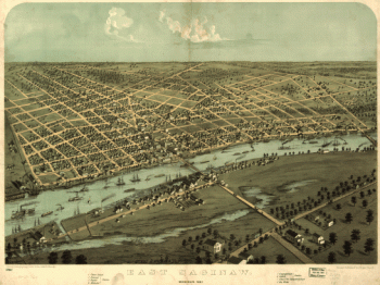
East Saginaw, Michigan, 1867 / drawn & published by A. Ruger
Price range: $39.95 through $69.95 -
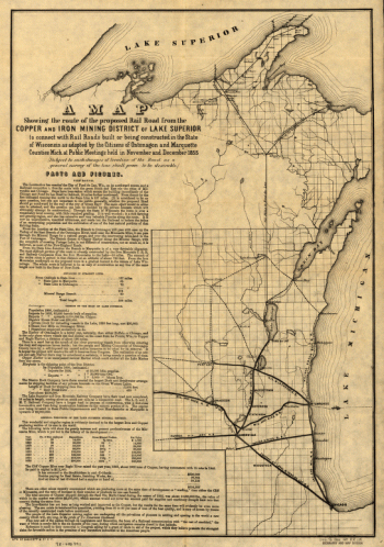
Route of the proposed rail road from the Copper and Iron Mining District of Lake Superior
Price range: $39.95 through $69.95

![Panoramic view of the city of Jackson, Michigan 1881. [By] A. Ruger. Beck & Pauli Lith.](https://www.ushistoricalarchive.com/wp-content/uploads/nc/data/products/im/sm/mi/b36-350x228.gif)
![Saginaw City [Michigan 1867] Drawn from nature by A. Ruger.](https://www.ushistoricalarchive.com/wp-content/uploads/nc/data/products/im/sm/mi/b22-350x275.gif)