-

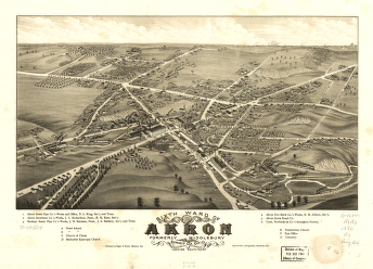
Sixth ward of Akron, formerly Middlebury, Summit Co., Ohio 1882. Beck & Pauli, lithographers.
Price range: $39.95 through $69.95 -
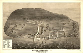
View of Johnson's Island, near Sandusky City, O. Sketched by Edward Gould.
Price range: $39.95 through $69.95 -
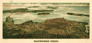
Sandusky, Ohio. Gugler Litho. Co.
Price range: $39.95 through $69.95 -
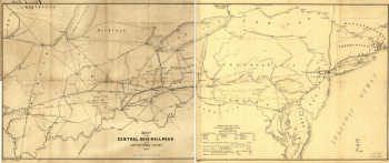
Map of the Central Ohio Railroad and connecting lines.
Price range: $39.95 through $69.95 -
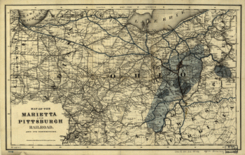
Map of the Marietta and Pittsburgh Railroad and its connections.
Price range: $39.95 through $69.95 -
Map of Logan county, Ohio
Price range: $39.95 through $69.95 -
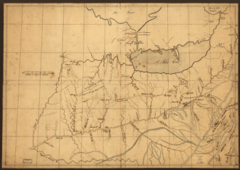
A trader's map of the Ohio country before 1753.
Price range: $39.95 through $69.95 -
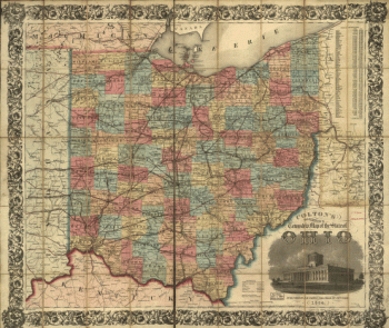
Colton's railroad & township map of the state of Ohio, drawn by George W. Colton, engraved by J M. Atwood.
Price range: $39.95 through $69.95 -
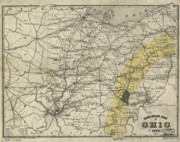
Rail road map of Ohio 1873.
Price range: $39.95 through $69.95 -
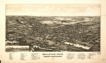
Bellevue, Ohio, Sandusky & Huron counties 1888. Burleigh Lith. Est.
Price range: $39.95 through $69.95 -
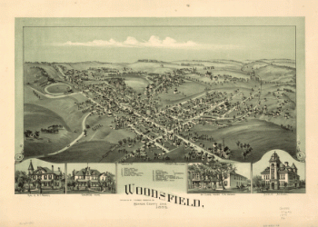
Woodsfield, Monroe County, Ohio, 1899
Price range: $39.95 through $69.95 -
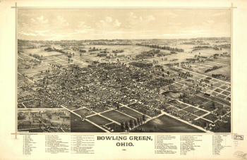
Bowling Green, Ohio 1888. Burleigh Lith. Est.
Price range: $39.95 through $69.95 -
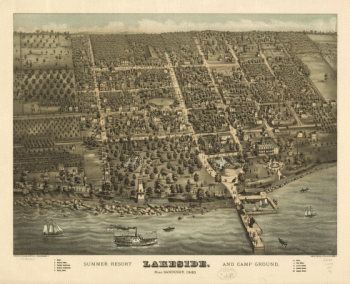
Lakeside summer resort and camp ground, near Sandusky, Ohio. Sinz & Fausel Lith.
Price range: $39.95 through $69.95 -
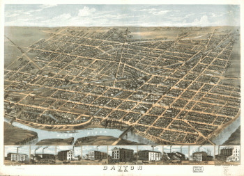
Dayton, Ohio 1870.
Price range: $39.95 through $69.95 -
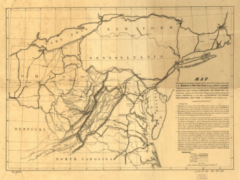
The extension of the route of the Baltimore & Ohio Rail Road through north western Virginia from the Potomac to the Ohio river
Price range: $39.95 through $69.95 -
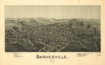
Barnesville, Ohio 1899
Price range: $39.95 through $69.95 -
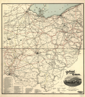
Railroad map of Ohio
Price range: $39.95 through $69.95 -
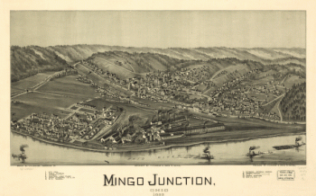
Mingo Junction, Ohio 1899
Price range: $39.95 through $69.95 -
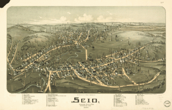
Scio, Harrison County, Ohio
Price range: $39.95 through $69.95 -
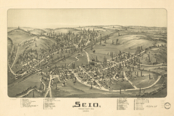
Scio, Harrison County, Ohio 1899
Price range: $39.95 through $69.95 -
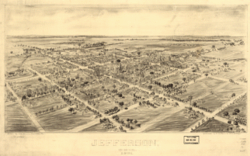
Jefferson, Ohio 1901. Drawn by T. M. Fowler. Morrisville, Pa.
Price range: $39.95 through $69.95 -
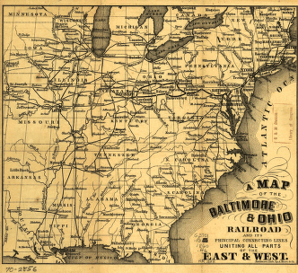
A map of the Baltimore & Ohio Railroad and its principal connecting lines uniting all parts of the East & West.
Price range: $39.95 through $69.95 -
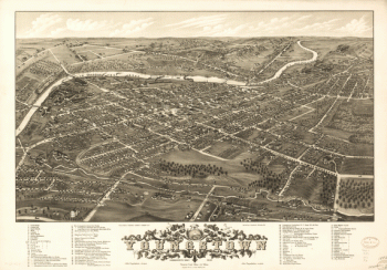
Panoramic view of the city of Youngstown, county seat of Mahoning Co., Ohio
Price range: $39.95 through $69.95 -
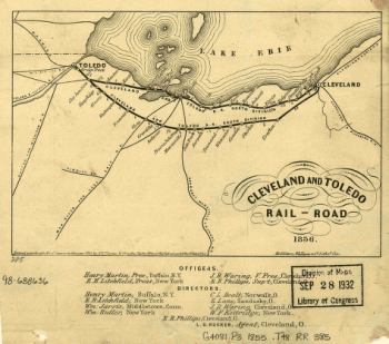
Cleveland and Toledo Rail-Road 1856
Price range: $39.95 through $69.95 -
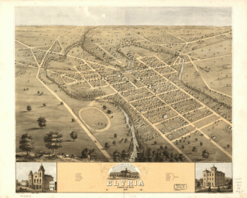
Bird's eye view of the town of Elyria, Lorain Co., Ohio 1868
Price range: $39.95 through $69.95 -
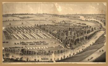
Army camp at Gaylord's Grove, Cuyahoga Falls, Ohio
Price range: $39.95 through $69.95 -
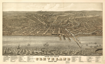
Birds eye view of Cleveland, Ohio 1877. A. Ruger artist. Lith. by Shober & Carqueville.
Price range: $39.95 through $69.95 -
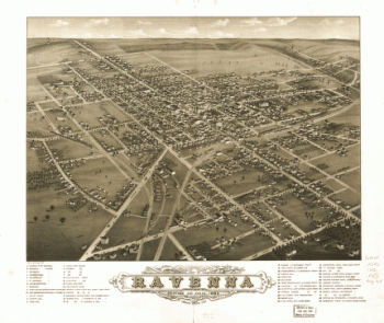
Panoramic view of the city of Ravenna, county seat of Portage Co., Ohio 1882.
Price range: $39.95 through $69.95 -
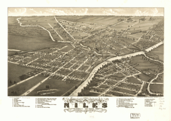
Panoramic view of the city of Niles, Trumbull Co., Ohio 1882. Beck & Pauli Lith.
Price range: $39.95 through $69.95 -
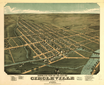
Birds eye view of the city of Circleville, Pickaway County, Ohio 1876. Krebs Lithographing Company.
Price range: $39.95 through $69.95 -
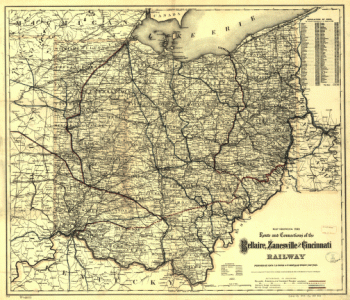
Map showing the route and connections of the Bellaire, Zanesville and Cincinnati Railway.
Price range: $39.95 through $69.95 -
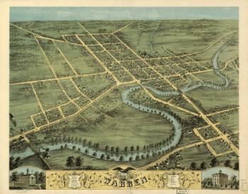
Bird's eye view of Warren, Trumbull County, Ohio 1870. Merchants Lithographing Co.
Price range: $39.95 through $69.95 -
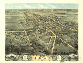
Bird's eye view of Norwalk, Huron County, Ohio 1870. Merchants Lithographing Co.
Price range: $39.95 through $69.95 -
Toledo, Ohio 1876. [By] A. Ruger. Chas. Shober & Co. props. Chicago Lith. Co.
Price range: $39.95 through $69.95 -
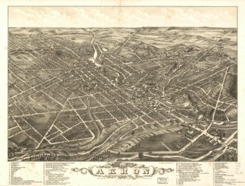
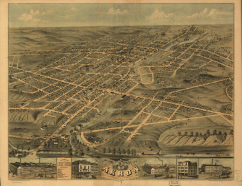
Panoramic view of the city of Akron, Summit County, Ohio 1882. Beck & Pauli, lithographers.
Price range: $39.95 through $69.95 -
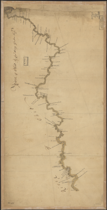
River of Ohio.
Price range: $39.95 through $69.95 -
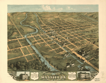
Bird's eye view of Massillon, Stark County, Ohio 1870. Lithographed by Merchants Lith. Co.
Price range: $39.95 through $69.95 -
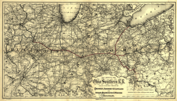
Ohio Southern railroad and its connections
Price range: $39.95 through $69.95 -
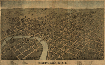
Birds eye view of Columbus, Ohio / drawn by H.H. & O.H. Bailey.
Price range: $39.95 through $69.95 -
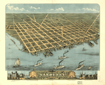
Bird's-eye-view of the city of Sandusky, Erie County, Ohio 1870. Drawn by A. Ruger. Chicago Lithographing Co.
Price range: $39.95 through $69.95 -
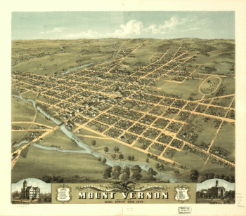
Bird's eye view of the city of Mount Vernon, Knox County, Ohio 1870. Merchants Lith. Co.
Price range: $39.95 through $69.95 -
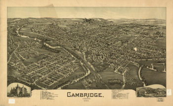
Cambridge, Ohio 1899. Drawn by T. M. Fowler.
Price range: $39.95 through $69.95 -
Bird's eye view of the city of Akron, Summit County, Ohio 1870. Drawn by A. Ruger. Chicago Lithographing Co.
Price range: $39.95 through $69.95 -
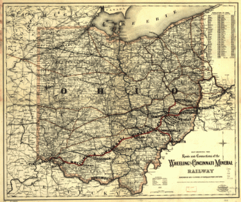
Map showing the route and connections of the Wheeling and Cincinnati Mineral Railway.
Price range: $39.95 through $69.95 -
A plan of the section of land on which the Believers live in the state of Ohio, Nov. 7th, 1807.
Price range: $39.95 through $69.95 -
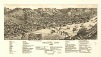
Bird's eye view of Bellaire, Ohio 1882. H. Wellge, del. Beck & Pauli, lithographers.
Price range: $39.95 through $69.95 -
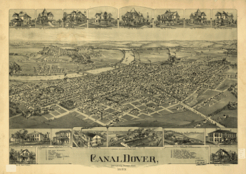
Canal Dover, Tuscarawas County, Ohio 1899. Drawn by A. E. Downs.
Price range: $39.95 through $69.95 -
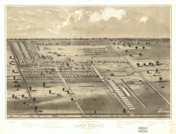
Bird's eye view of Camp Chase near Columbus, Ohio. Drawn by A. Ruger.
Price range: $39.95 through $69.95
![Toledo, Ohio 1876. [By] A. Ruger. Chas. Shober & Co. props. Chicago Lith. Co.](https://www.ushistoricalarchive.com/wp-content/uploads/nc/data/products/im/sm/oh/b48-350x202.gif)