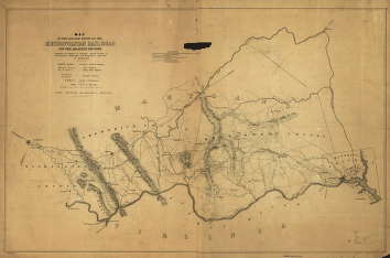
Map of the located route of the Metropolitan Rail Road and the adjacent country comprising the District of Columbia and the counties of Montgomery, Frederick, and Washington in the state of Maryland, Francis Dodge president M.R.R. Company, Edmund French, chief engineer, W. R. Hutton draughtsman, completed April 30, 1855 from surveys made in 1853 and 1854. Topographical map of part of Maryland showing relief by hachures, drainage, cities and towns, canals, the Washington Aqueduct, roads, and railroads with milege on the main survey line. Chartered in 1853. Hutton, Wm. R. (William Rich), 1826-1901. CREATED/PUBLISHED [Washington, 1855] Scale 1:126,720.


