Home
All Products
Historic Maps
American Indian Maps
Birds Eye View Maps
Civil War Maps
Panoramic Maps
Railroad Maps
Revolutionary War Maps
State Maps
Historic Prints
Civil War Prints
Civil War Posters
Historic Portraits
Presidential Portraits
Contact Us
0
0
press
Enter
to search
Showing all results:
No products found.
Home
/
Revolutionary War Maps
/
New England
/
Colchester, May the: 6:th: Day: AD: 1765
$
17.95
–
$
47.95
SKU: rwne1
Paper Size
Choose an option
12" x 18"
18" x 24"
24" x 36"
Clear
Quantity
Qty
Add to cart
Description
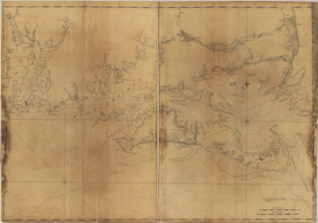
Foot, Israel. CREATED/PUBLISHED [1765]
SKU:
rwne1
Category:
New England
Related products
Coast of New England from Chatham Harbor to Narragansett Bay
$
17.95
–
$
47.95
An Accurate map of New Hampshire in New England, from a late survey
$
17.95
–
$
47.95
Plan, Lake Champlain from Fort St John's to Ticonderoga, with the soundings, rocks, shoals, and sands, surveyed in the years 1778, 1779
$
17.95
–
$
47.95
Plan von Rhode Island, und deren dem comando des Herrn General Majors Presgott inf dies-malig befundlichen campements Aufgenommen und gezeichnet den 8ten July 1777, von J C Schiffer, Artiy Lieut
$
17.95
–
$
47.95
Search Product or SKU
×
Home
All Products
Historic Maps
American Indian Maps
Birds Eye View Maps
Civil War Maps
Panoramic Maps
Railroad Maps
Revolutionary War Maps
State Maps
Historic Prints
Civil War Prints
Civil War Posters
Historic Portraits
Presidential Portraits
Contact Us
Cart
0
Cart
Close
Updating…
No products in the cart.
Continue shopping