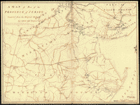
Drawn by Capt. Holland. Engraved by Thomas Jefferys, geographer to His Majesty.–and improved from the modern surveys of those colonies down to the year 1776. Holland, Samuel, 1728-1801. CREATED/PUBLISHED London, Robt. Sayer & John Bennett, 1775 [i.e. 1776] NOTES Scale ca. 1:650,000. Hand colored. LC copy deteriorated in margins. Relief shown pictorially. Shows administrative divisions. Insets: A chart of the mouth of Hudson's River, from Sandy Hook to New York.–A plan of the city of New York.–Plan of Amboy, with its environs, from an actual survey. With part of Pensilvania, and the province of Quebec. Drawn by Capt. Holland. Engraved by Thomas Jefferys, geographer to His Majesty.–and improved from the modern surveys of those colonies down to the year 1776. Holland, Samuel, 1728-1801. CREATED/PUBLISHED London, Robt. Sayer & John Bennett, 1775 [i.e. 1776] NOTES Scale ca. 1:650,000. Hand colored. LC copy deteriorated in margins. Relief shown pictorially. Shows administrative divisions. Insets: A chart of the mouth of Hudson's River, from Sandy Hook to New York.–A plan of the city of New York.–Plan of Amboy, with its environs, from an actual survey.

The provinces of New York and New Jersey, with part of Pensilvania, and the province of Quebec
$17.95 – $47.95
SKU: rwnjar104300
Related products
-

A sketch of the operations of His Majesty's fleet
$17.95 – $47.95 -
A map of part of the province of Jersey
$17.95 – $47.95 -
The provinces of New York, and New Jersey
$17.95 – $47.95 -
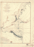
Carte de l'entree de la rivière d'Hudson
$17.95 – $47.95