From a trigonometrical survey under the direction of A. D. Bache, Superindent of the survey of the coast of the United States. Triangulation by C. O. Boutelle, Assist. Hydrography by the parties under the command of Lieuts. Commdg. J. N. Maffit and C. M. Fauntleroy, U.S.N, Assists. United States Coast Survey. CREATED/PUBLISHED [Washington, U.S. Coast Survey], 1862. NOTES Scale 1:60,000. Detailed nautical chart showing Hilton Head Island and vicinity. Indicated are soundings, bottom contours, and vegetation. Includes sailing directions.
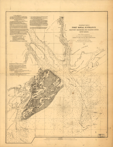
Preliminary chart of Port Royal entrance. Beaufort, Chechessee, and Colleton Rivers, South Carolina
Price range: $39.95 through $69.95
SKU: smsc31
Related products
-

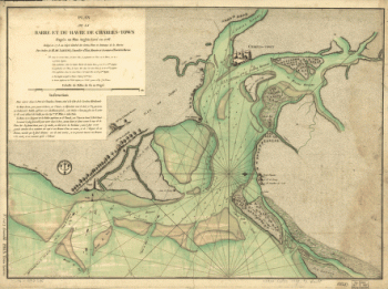
Plan de la barre et du havre de Charles-Town
Price range: $39.95 through $69.95 -
Route of marches of the army of Genl. W. T. Sherman, from Atlanta, Ga. to Goldsboro, N.C. [1861-65]
Price range: $39.95 through $69.95 -
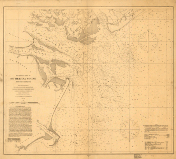
Preliminary chart of St. Helena Sound, South Carolina
Price range: $39.95 through $69.95
![Route of marches of the army of Genl. W. T. Sherman, from Atlanta, Ga. to Goldsboro, N.C. [1861-65]](https://www.ushistoricalarchive.com/wp-content/uploads/nc/data/products/im/sm/sc/b65-350x226.gif)