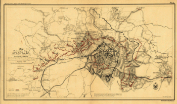
From the passage of Peach Tree Creek, July 19th 1864, to the commencement of the movement upon the enemy's lines of communication, south of Atlanta, August 26th 1864 Compiled by authority of the Hon. the Secretary of War in the Office of the Chief of Engineers, U.S.A., 1875. United States. Army. Corps of Engineers. CREATED/PUBLISHED N.Y., Julius Bien & Co., photo lith., [1875] NOTES Scale ca. 1:32,000. Insets: A portion of the Confederate defenses of Atlanta. Scale ca. 1:1300. A portion of the U.S. defensive works erected after the capture of Atlanta. Scale 1:1200. Confederate and Union defenses shown in the insets are keyed to the map by the letters A to G and the numbers 7 to 12 respectively. Detailed map showing fortifications, headquarters, location and dates of battles, street outline of Atlanta, roads, railroads, vegetation, drainage, relief by hachures, towns, mills, churches, the location of rural houses, and the names of residents.

Map illustrating the military operations in front of Atlanta, Ga.
$17.95 – $47.95
SKU: smga79
Related products
-

Map illustrating the siege of Atlanta, Ga.
$17.95 – $47.95 -
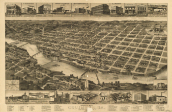
Perspective map of Columbus, Ga.
$17.95 – $47.95 -
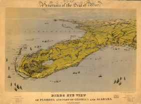
Birds eye view of Florida and part of Georgia and Alabama
$17.95 – $47.95 -
Map of the Confederate States of America. [1861-65]
$17.95 – $47.95
![Map of the Confederate States of America. [1861-65]](https://www.ushistoricalarchive.com/wp-content/uploads/nc/data/products/im/sm/ga/b75-350x492.gif)