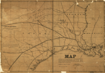
Together with its proposed branches, connections and extensions in Louisiana, Arkansas & Texas; also its connecting steamship routes from Berwicks Bay to ports in the Gulf of Mexico, together with the advantages in point of directness & diminished distance to the Pacific Coast, New Orleans, La. January 24th, 1859. Bayley, G. W. R. CREATED/PUBLISHED New Orleans, 1859. NOTES Scale 1:1,267,200. Outline map of the south-central states from Mississippi to the Rio Grande. Shows the 'Wheat Region of Texas.' Indicates completed, located and proposed lines. Table of distances in left side of map.


