3 or 4 miles below the mouth, a portion of which is divided into 17 lots W. Crawford, surv. Crawford, William, 1732-1782. CREATED/PUBLISHED 1771. NOTES Scale ca. 1:20,000. Title from Lawrence Martin's The George Washington atlas. 1932. Cover title: George Washington; survey of land in Ohio, a grant from the Colony of Virginia to Washington for military services … Oriented with north toward the lower left. Annotated by George Washington: Patented in the name of George Washington. Includes table of 'River courses & distances' annotated by George Washington and 'A table to explain this plat.'

Plat of a survey of 2,314 acres of land, being the first large bottom on the east side of the Ohio River
$17.95 – $47.95
SKU: smoh69
Related products
-

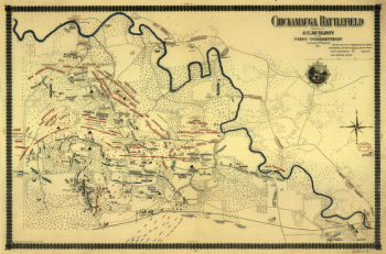
Chickamauga battlefield
$17.95 – $47.95 -
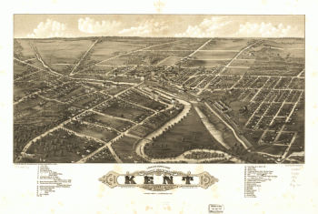
Panoramic view of the city of Kent, Portage County, Ohio 1882.
$17.95 – $47.95