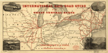
Showing what proportion lies north of the parallel of South Bend of Lake Michigan. It will be seen at a glance, that the unbroken line of communication with the Atlantic seaboard, and the only winter route for northern Indiana, northern Illinois, Michigan, Iowa, Wisconsin, and Minnesota, will be by the Michigan Southern Railway, and south shore of Lake Erie. Jervis, John B. (John Bloomfield), 1795-1885. CREATED/PUBLISHED New York, [1850] SUMMARY Outline map of the north-central United States showing the canals and the railroad network and naming the Michigan Central and the Michigan Southern Railway. John B. Jervis was chief engineer on the Mohawk & Hudson Railroad in 1831.

Map of the northwestern states
$17.95 – $47.95
SKU: smmi2
Related products
-

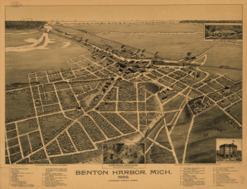
nton Harbor, Mich. 1889.
$17.95 – $47.95 -
International rail road guide of the Great Central Route.
$17.95 – $47.95