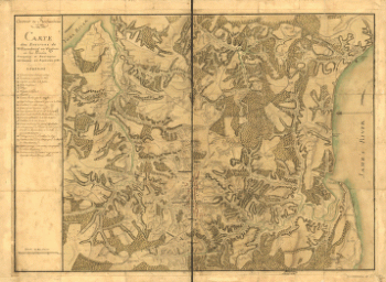
Washington, George, 1732-1799. CREATED/PUBLISHED 1774?] NOTES Scale ca. 1:40,000. Oriented with north toward the lower left. Individual surveys dated 1771 through 1774, performed by 'Mr. Saml. Lewis' and 'Wm. Crawford' with the assistance of John Floyd. Authorship of the map as a composite work ascribed to George Washington in Lawrence Martin's The George Washington atlas. Includes descriptive index-tables for survey tracts 1-5 and 7-8. Accompanied by a survey certificate describing survey tracts 6 and 7.

Eight survey tracts along the Kanawha River, WVa showing land granted to George Washington and others
$17.95 – $47.95
SKU: rwso68
![[Zehn Karten und Ansichten den Schlachtfelden des amerikanischen Unabhangigkeitskreiges in den Staaten Pennsylvanien und New York]](https://www.ushistoricalarchive.com/wp-content/uploads/nc/data/products/im/rw/south/b51-350x242.gif)
![[Zehn Karten und Ansichten den Schlachtfelden des amerikanischen Unabhangigkeitskreiges in den Staaten Pennsylvanien und New York]](https://www.ushistoricalarchive.com/wp-content/uploads/nc/data/products/im/rw/south/b50-350x242.gif)