Map showing the Sodus Point & Southern Railroad and its connections. of the northeastern United States showing drainage, cities and towns, county boundaries, coal in Pennsylvania, and the railroad network with emphasis on the main line. Chartered in 1852. Reorganized in 1875 with the Geneva, Hornellsville, and Pine Creek Railroad. In 1882 became the Sodus Bay and Southern Railroad. G.W. & C.B. Colton & Co. CREATED/PUBLISHED New York, 1872. Scale 1:1,267,200.

Sodus Point and Southern Railroad
$17.95 – $47.95
SKU: rrsz13
Related products
-

Virginia Central Railroad Company
$17.95 – $47.95 -
Winchester and Potomac Railroad Company
$17.95 – $47.95 -
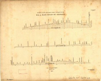
Western and Atlantic Railroad Company
$17.95 – $47.95 -
Union Pacific Railroad Company
$17.95 – $47.95