G.W. & C.B. Colton & Co. CREATED/PUBLISHED New York, 1882. NOTES Scale ca. 1:800,000. 'Map Designed by Thomas R. Sharp, Consulting Engineer '. Map of Ohio showing drainage, cities and towns, townships and countries, and the railroad network with emphasis on the main line.

Map showing the route and connections of the Wheeling and Cincinnati Mineral Railway.
$17.95 – $47.95
SKU: smoh58
Related products
-

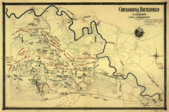
Chickamauga battlefield
$17.95 – $47.95