From surveys supplied by officers of the army. Entered according to Act of Congress in the year 1862 by D. A. Heald. Heald, D. A. 1818-1900. (Daniel Addison), CREATED/PUBLISHED [New York, 1864] NOTES Scale ca. 1:445,000. Map of eastern Virginia showing roads, railroads, towns, drainage, and some relief by hachures. Battlefields are identified by crossed swords. Inset: The strategic points of east Tennessee, northern Alabama, and Georgia, from the U.S. official military map, 1864. Entered according to Act of Congress in the year 1864, by D. A. Heald . . . Scale ca. 1:1,300,000.

The approaches from Washington, to Richmond
$17.95 – $47.95
SKU: smal50
Related products
-

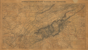
Mountain region of North Carolina and Tennessee
$17.95 – $47.95