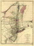
With the channels depth of water, rocks, shoals &c. and the country adjacent, from Sandy-Hook, New York and bay to Fort Edward, also the communication with Canada by Lake George and Lake Champlain, as high as Fort Chambly on Sorel River. 1776. Sauthier, Claude Joseph. CREATED/PUBLISHED London, Wm. Faden [1777] NOTES Scale 1:253,440, 4 miles to 1 in. Hand colored. Relief shown by hachures. Depths shown by soundings.

Hudsons River – topographical
$17.95 – $47.95
SKU: rwnjar106900
Related products
-

The provinces of New York and New Jersey
$17.95 – $47.95 -
Operations in America No 2
$17.95 – $47.95 -
A map of the provinces of New-York and New Jersey
$17.95 – $47.95 -
Carte de l'entree de la rivière d'Hudson
$17.95 – $47.95